By William Madouk Garang
South Sudan Government has urged the public, and government officials to stop using unauthorized South Sudan maps that omit some of its territorial parts.
Chairman of the South Sudan Joint Border Commission with Sudan, Michael Makuei Lueth said vast majority are using non-governmental organizations’ relief maps and an unofficial map from Google that misplace integral parts of the country to Sudan.
“I have seen so many maps and people are using it, some of these maps were presented during the 6th Governors’ forum and others were presented in so many places and these maps are wrong maps,” said Makuei who is also the government Spokesperson.
“Those are NGOs maps for delivering relief [services] that people are still using, we have a map that is approved by the government of South Sudan – and that is the map we are supposed to be using” he continued.
He stated that the official map of South Sudan was printed and distributed to ministries and states unfortunately people are still using maps that they download from Google that cutoff big chunk of areas.
“Maps that you are using are the ones that will be used against you if you enter into a border dispute with any country. Therefore, we are supposed to use one official map and maintain it” he noted.
“For [Sudan] them they have already introduced digital map which covers all the disputed areas and claimed areas – in our part we must do the same” he said.
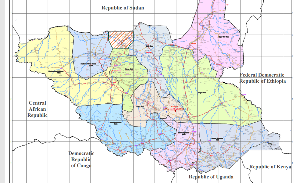
Makuei stated that the official South Sudan map [pictured] covered all the disputed border areas between Sudan into its original historical places as boundaries stood of January 1, 1955.
The government mouthpiece cited that illegal maps miss out the contested border areas – which are; Abyei, Kaka town, Debbat el Fukhar, Jebel Magenis [Kit-Gwang], the 14-Mile area, south of Bahr el Arab, Hafrat el Nukhas, Kafia Kingi, Panthou [Heglig] and Karasana.
“We cannot bring our border to river Kiir and we have a vast land up there that we use to leave it to Sudan – almost over 30 miles before the river Kiir. We also miss out Maram – who own Maram? It was headquarters of late Abdelbagi Ayii” he explained.
“In Upper Nile, we are in west of Kaka town for over 60 kilometers and Sudan government is even claiming Kaka town – and Kaka town is here near the river. Sudan claims that it belongs to them because it’s called Kaka Tijaria,” he added.
According to him, Kaka town was named Kaka Tijaria because it was a border trade area where slaves were being shipped to Omdurman – it was a port for transporting slaves.
In October 2022, Sudan and South Sudan started deliberating on their position papers on the border disputes.
This was done as the continuation of review meetings of the South Sudan and the Sudan Joint Border Commission that was held in the Sudan capital, Khartoum in June, whereby the two countries presented their positions.
The chairperson of the South Sudan Joint Border Commission, Mr. Makuei pointed out that all position papers are being discussed by the parties.
“We met in order to continue with deliberations on the issues of the borders, in the last meeting the parties presented position papers and all these positions papers were now read and discussed by the parties” Makuei told local media earlier.
“We have come together in order to deliberate and exchange views and discuss the way forward after the presentations of the position of the parties.”
For his part, the Co- chairperson of the Sudan Joint Border Commission, Dr. Mohaz Mohamed Tongo stated that all the parties have presented their final position regarding the borderline 01/01/1956.
“We have reached serious points and everyone has presented their final position regarding the borderline 01/01/1956, and will deliberate with open heart” Mohaz Mohamed said.
“We will listen to each of us, and will make progress, and we will assure the two countries that we will do our best to end the issue of border in a very good manner as soon as possible” he assured.


