
The council of States has started its first sitting of the year 2023 with the swearing in of seven members representing different political parties.
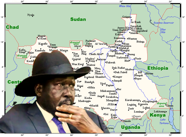
As the House is back to business after the recess, MPs are expected to have a hot debate next week on matters of reported encroachment by three neighboring countries; Uganda, Kenya and Sudan.
Mr. James Magok Ater, the Deputy Chairperson of Economic and Public Account committee, said the first session was administering the oath to seven members who were recently appointed.
“The agenda of the day was the administration of oaths for 7 members from various parties and states and also it marks the first session,” said Ater who is also the acting spokesperson of the House.
He also added that the Rt. Speaker Deng Deng Akoon, passionately hailed the new members to the House.
MP Ater revealed that the Council of States will now enact and pass the pending raft of bills, adding that members who came back from recess raised points of information, more especially on border intrusion.
“We have a lot of information coming from members who went on recess and most especially the Ruweng Administrative Area and Eastern Equatoria States,” he noted.
“And this information concerns the encroachment of the government of Sudan, Uganda and that of Kenya. So, all this will be discussed in the next agenda that may be discussed on the coming week,” he continued.
A month ago, local authorities in Eastern Equatoria State accused Kenya of encroaching into South Sudan’s territory after Kenyan Forces [KDF] allegedly crossed to Nakodok on the South Sudanese side but Nairobi denies any of the claims.
Clashes between Toposa and Turkana communities, who share a border, had reportedly claimed dozens of lives on both sides.
In 2009, Kenya and the then-Government of Southern Sudan signed a deal to set up a temporary border control post at Nadapal to facilitate cross-border movement of people, goods, and services.
Several MPs have criticized the agreement and demanded that parliament reconvene to discuss pre-independence issues.
Advancement was reached after President Salva Kiir dispatched a high-level delegation led by his office minister to meet Kenyan President, William Ruto to seek avenues of resolving the border issue using diplomatic means.
The two countries also claim ownership of a border region called the Ilemi Triangle, supposedly a mineral-rich area measuring about 1,000 square kilometers.
On February, also the government official in Ruweng administrative area said the Sudanese armed forces gave the residents of Alel in Wunkur county a 72 hours ultimatum to leave the area in a fresh border row.
Area information minister, James Arop claimed that Sudanese Rapid Forces crossed to the border and issued an ultimatum, although in dialogue with Sudanese authorities. He said national government have been notified on the matter.
The oil-rich Ruweng area borders Sudan’s Western Kordofan state. The area is also rich in animal and fishery resources and a home to two lakes – Lake Jau and Lake No, where Bahr el Ghazal River ends and joins the White Nile.
In October 2022, Sudan and South Sudan started deliberating on their position papers on the border disputes.
The two countries are contesting the border areas of Abyei, Kaka, Debbet el Fukhar, Jebel Maganis, the 14-miles area, South of Bahr el Arab, Hafrat Nuhus and Kafia Kingi.
Last year, South Sudan Minister of information, Michael Makuei appealed to the public, and government officials to stop using unauthorized South Sudan maps that omit some of its territorial parts.
Makuei who is also the chairman of the South Sudan Joint Border Commission with Sudan, said vast majority are using non-governmental organizations’ relief maps and an unofficial map from Google that misplace integral parts of the country to Sudan.
He stated that the official map of South Sudan was printed and distributed to ministries and states unfortunately people are still using maps that they download from Google that cutoff big chunk of areas.
“Maps that you are using are the ones that will be used against you if you enter into a border dispute with any country. Therefore, we are supposed to use one official map and maintain it,” he said during SPLM Liberation Council meeting.
By William Madouk
The council of States has started its first sitting of the year 2023 with the swearing in of seven members representing different political parties.
As the House is back to business after the recess, MPs are expected to have a hot debate next week on matters of reported encroachment by three neighboring countries; Uganda, Kenya and Sudan.
Mr. James Magok Ater, the Deputy Chairperson of Economic and Public Account committee, said the first session was administering the oath to seven members who were recently appointed.
“The agenda of the day was the administration of oaths for 7 members from various parties and states and also it marks the first session,” said Ater who is also the acting spokesperson of the House.
He also added that the Rt. Speaker Deng Deng Akoon, passionately hailed the new members to the House.
MP Ater revealed that the Council of States will now enact and pass the pending raft of bills, adding that members who came back from recess raised points of information, more especially on border intrusion.
“We have a lot of information coming from members who went on recess and most especially the Ruweng Administrative Area and Eastern Equatoria States,” he noted.
“And this information concerns the encroachment of the government of Sudan, Uganda and that of Kenya. So, all this will be discussed in the next agenda that may be discussed on the coming week,” he continued.
A month ago, local authorities in Eastern Equatoria State accused Kenya of encroaching into South Sudan’s territory after Kenyan Forces [KDF] allegedly crossed to Nakodok on the South Sudanese side but Nairobi denies any of the claims.
Clashes between Toposa and Turkana communities, who share a border, had reportedly claimed dozens of lives on both sides.
In 2009, Kenya and the then-Government of Southern Sudan signed a deal to set up a temporary border control post at Nadapal to facilitate cross-border movement of people, goods, and services.
Several MPs have criticized the agreement and demanded that parliament reconvene to discuss pre-independence issues.
Advancement was reached after President Salva Kiir dispatched a high-level delegation led by his office minister to meet Kenyan President, William Ruto to seek avenues of resolving the border issue using diplomatic means.
The two countries also claim ownership of a border region called the Ilemi Triangle, supposedly a mineral-rich area measuring about 1,000 square kilometers.
On February, also the government official in Ruweng administrative area said the Sudanese armed forces gave the residents of Alel in Wunkur county a 72 hours ultimatum to leave the area in a fresh border row.
Area information minister, James Arop claimed that Sudanese Rapid Forces crossed to the border and issued an ultimatum, although in dialogue with Sudanese authorities. He said national government have been notified on the matter.
The oil-rich Ruweng area borders Sudan’s Western Kordofan state. The area is also rich in animal and fishery resources and a home to two lakes – Lake Jau and Lake No, where Bahr el Ghazal River ends and joins the White Nile.
In October 2022, Sudan and South Sudan started deliberating on their position papers on the border disputes.
The two countries are contesting the border areas of Abyei, Kaka, Debbet el Fukhar, Jebel Maganis, the 14-miles area, South of Bahr el Arab, Hafrat Nuhus and Kafia Kingi.
Last year, South Sudan Minister of information, Michael Makuei appealed to the public, and government officials to stop using unauthorized South Sudan maps that omit some of its territorial parts.
Makuei who is also the chairman of the South Sudan Joint Border Commission with Sudan, said vast majority are using non-governmental organizations’ relief maps and an unofficial map from Google that misplace integral parts of the country to Sudan.
He stated that the official map of South Sudan was printed and distributed to ministries and states unfortunately people are still using maps that they download from Google that cutoff big chunk of areas.
“Maps that you are using are the ones that will be used against you if you enter into a border dispute with any country. Therefore, we are supposed to use one official map and maintain it,” he said during SPLM Liberation Council meeting.